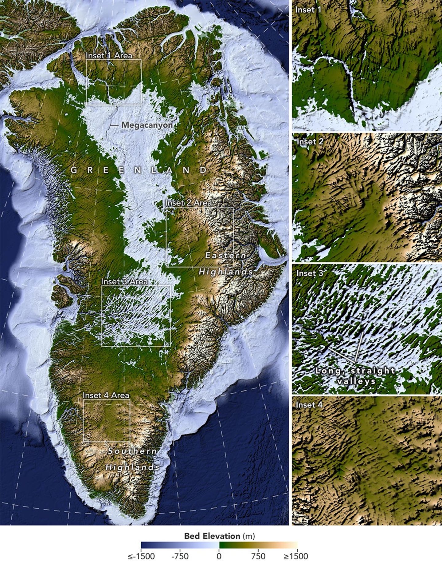
NASA scientists have produced the most detailed map yet of the bedrock hidden beneath Greenland’s 1.7‑million‑square‑kilometre ice sheet, revealing a vast network of subglacial valleys that were previously invisible to the eye.
The new map was created with a technique called Ice Flow Perturbation Analysis, which interprets subtle bumps and dips in the ice surface that result from the underlying topography. By analysing satellite imagery of the ice sheet, researchers were able to infer the shape of the terrain below and update the BedMachine Greenland dataset, a high‑resolution model of the ice‑covered landscape.
Using the method, the team manually mapped 1,943 valleys beneath the ice, about one‑third of which had not been identified before. Roughly half of the valleys that were already included in BedMachine Greenland now appear to extend farther inland than previously recorded, in some cases by hundreds of kilometres. The most striking new features are long, straight valleys in the west‑central region that run in a consistent southwest‑northeast direction.
Many of the valleys seem to originate in the southern and eastern highlands, where the ice sheet is thought to have first formed. Near the eastern highlands the map shows a mountain range with interconnected valleys that increase in relief toward the coast, suggesting alpine‑style landforms that may have survived since at least the Pliocene. The straight, uniformly aligned valleys in the west‑central area hint at a tectonic influence, a possibility that “is a riddle to us,” said NASA cryospheric scientist Joe MacGregor.
The angles at which the valleys branch also point to a complex origin. Their relatively wide branching angles imply that surface water alone could not have carved them; a widespread groundwater system likely eroded the rock before the ice sheet covered the area.
Understanding the valley network matters for predicting how Greenland’s ice sheet will behave. Ice flows concentrate in valleys, forming glaciers that eventually calve into fjords at the coast. As the ice retreats, flow will continue to focus along these pre‑existing pathways, potentially accelerating the loss of ice in the interior. “The better we understand the topography now,” MacGregor said, “the better sense we’ll have of what it will look like in the longer term—beyond the next decade or two—as faster ice flow propagates into Greenland’s interior.”
Source: Chartrand, A. M., et al. (2026) “A Vast Valley Network Beneath the Greenland Ice Sheet.” Geophysical Research Letters, 53(13), e2026GL122028. Map by Lauren Dauphin, NASA Earth Observatory.
<small>Source: NASA — read the original story there.</small>


