El Niño under way and threatens weather extremes, scientists say

El Niño - the natural Pacific weather pattern that pushes up global temperatures - has officially begun, US scientists say.
The US National Oceanic and Atmospheric Administration (NOAA) has declared that El Niño conditions are now under way in the tropical Pacific, with sea surface temperatures having risen sharply in recent months.
Many forecasts suggest this could end up as a so-called "super" El Niño, and even be among the strongest ever recorded.
Coming on top of decades of human-caused warming, it could bring another record-hot year - most likely in 2027 - with disruption to weather, food supplies and economies running well into that year.
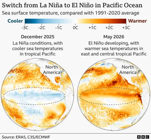
This announcement by NOAA is not a surprise as forecasters have expected this warming phase since the cooler "sister" pattern, La Niña, faded at the end of last year.
Sea surface temperatures in the central and tropical Pacific have now passed the 0.5C-above-average threshold that US scientists use to define an El Niño event.
"El Niño conditions developed over the past month, as shown by above-average sea surface temperatures (SSTs) across the central to eastern equatorial Pacific Ocean," the agency said.
NOAA has also seen the winds above the equatorial Pacific begin to shift - a sign that the atmosphere is now responding to the warmer ocean, not just the ocean warming on its own.
What has surprised the researchers is how confident the computer models already are about its strength.
El Niño's intensity is measured by how far sea surface temperatures rise above average in a key zone of the Pacific.
A strong event is defined as more than 1.5C above average; a very strong one above 2C.
According to NOAA's June outlook, "there is a 63% chance of a very strong El Niño during November-January, that would rank among the largest El Niño events in the historical record going back to 1950," the agency said.
The three strongest events since then have been in 1982/83, 1997/98 and 2015/16.
Some of the latest US and European (ECMWF) models go further, showing temperatures in the tropical Pacific potentially climbing more than 3C above average by the end of the year.
But the US agency urged some caution on what their strength prediction implies.
"Even very strong El Niño events do not lead to the expected impact everywhere, but stronger events can more significantly tilt the odds in favour of expected outcomes."
The bigger concern is that all this is happening on an already much hotter planet.
"We do need to worry about the impacts," said Prof Adam Scaife, head of monthly to decadal prediction at the UK Met Office.
"The current El Niño is… riding on top of a substantial amount of global warming.
"This means that the actual temperatures in affected regions could well be unprecedented, as the warming from El Niño is being topped up by climate change."
A very strong El Niño typically lifts global air temperatures by around 0.2C, releasing heat stored in the ocean into the atmosphere. That extra blast now lands on a world that is already setting records.
The year 2024 - the warmest on record - was boosted by an El Niño that was not even especially strong.
And despite the cooling drag of a La Niña event, 2025 still came in as the third warmest year on record, hotter even than the super El Niño year of 2016.

"At the end of this year and into 2027, we're likely to see very high temperatures globally," Prof Scaife said.
"In 2027, we're likely to see excess heat on top of the global warming we've already got, and that could easily lead to another year above 1.5 degrees [of warming above late-19th-Century levels]."

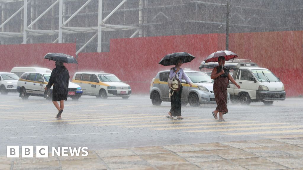
No two El Niños are alike, but the disruption is felt most sharply in the tropics.
Flooding is common in northern Peru and southern Ecuador, and can reach parts of East Africa, Central Asia and the southern United States.
At the same time, the risk of drought and wildfire rises across much of Australia, Indonesia and northern South America - hitting agriculture and global food stocks.
El Niño also tends to suppress Atlantic hurricanes, and forecasters already expect a quieter-than-average season.
"While that sounds like a good thing, for Central America that leads to a lot less rainfall and potentially drought conditions," said Liz Stephens, professor of climate risk and resilience at the University of Reading.
Even the UK feels it, if faintly: El Niño can tilt the odds towards a mild start and cold end to winter, though the links are loose.
For many, the forecast is far from abstract.
"An El Niño declaration is not just another weather forecast - for millions of people it is a deadly siren to be feared," said Mohamed Adow, director of campaign group Power Shift Africa.
"It means failed rains, dying crops, rising food prices, and families pushed to the edge yet again. In East Africa especially, this will land on communities already battered by droughts and floods in recent years."
Japan's Meteorological Agency (JMA) takes a similar view to NOAA, judging that El Niño conditions are present. It adds it is all but certain to last into the autumn.
Not every agency is ready to call it, though. Australia's Bureau of Meteorology (BoM) uses a stricter criterion, requiring sea surface temperatures to exceed 0.8C above average.
This week it said the tropical Pacific was "approaching El Niño conditions", with central Pacific temperatures already crossing its thresholds, but it stopped short of formally declaring the event had begun.
It expects El Niño to develop later this year, and says it could be strong.
El Niño occurs every two to seven years and usually lasts about a year.
There is still no conclusive proof that climate change is making these events stronger or more frequent - but a warming world can supercharge their effects.
Additional reporting by Erwan Rivault

<small>Source: BBC News</small>